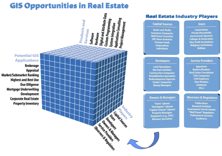
Real estate is one of the major industries in every country, comprising between 25% to 50% of any given nation’s assets. As shown in the diagram above, dozens of categories of Industry Players can use GIS in innumerable Potential GIS Applications, which in turn requires a broad spectrum of Products and Services.
Sooner or later all real estate professionals will be using a GIS. Those who are not already familiar with the technology need answers to these questions:
- Who else is using GIS in real estate? How long? How successfully?
- Does a GIS pay for itself? How Soon? In what ways?
- What is the likely risk-reward ratio? Cost-benefit ratio? Return on investment(ROI)?
- Can I operate a GIS myself, or do I have to hire a GIS technician?
- Where do I get the data? How much does the data cost? How often must it be updated?
- How easy is a GIS to learn? To remember how to use after serval days or even weeks of not using it?
- Can I buy off-the-shelf software and data that directly apply to my job, or do I have to customize a generic GIS?
- How does GIS differ from other computer technologies?
- How many sources of GIS software, hardware, data, customized programming, etc., are available? How do I find and choose among them?
- What are the best aspects of a GIS? The worst aspect?
- Can a complete GIS reside on a lap-top computer? Desk-top computer? Mini or mainframe computer? On a local area network, wide area network, and/or time-sharing system? On the Internet, either free or for a subscription fee?
- How does a GIS relate to multi-media technology, including digital photographs, full-motion videos, satellite imagery?
- Can I (easily) link a GIS to a desk-top publishing system, e.g., to produce marketing materials? To my current management information system (MIS)? To MS Office programs (Excel, PowerPoint, etc.)? To non-GIS real estate software such as those offered by Argus Software?
- How is the Internet changing the delivery and use of GIS software and data?
- How do I get started?
Castle Consulting India has a long track record of GIS educational books, professional journal articles, university lectureships, conference presentations, seminars and workshops. We offer customized educational support for everyone from “techies” to CEOs, in all the cells in the above three-dimensional matrix, at your offices or remotely via webinars. Let us show you how.