|
"Real Estate Industry Primed for Geographic Information Systems" The following text is Gil Castle's final draft of the real estate column appearing in Business Geographics, January/February 1993 Copyright © 1993 GIS World, Inc. |
Real estate may well be the vertical industry with the greatest market potential for GIS products and services. Among the reasons are the following:
| 1. | The industry is huge. More than half the world's wealth is in real estate. More than one-fourth of the Gross National Product of the United States derives directly from real estate. Three-fourths of the 400 largest personal fortunes in the United States are based on real estate. After payroll, real estate is the largest budgetary item for most private sector and public sector organizations, etc. |
| 2. | Due to severe economic problems in the industry, real estate professionals are becoming increasingly data-intensive and computer-literate. Excessive construction of commercial space throughout the 1980s, combined with diminished demand from the late 1980s onward, has resulted in free-falling rents, low sales prices, and high unemployment in the industry. The survivors � especially the ever more dominant institutional players (e.g., pension funds, banks, insurance companies) � are no longer willing to rely on the intuitive skills of deal makers. They want, instead, extensive and accurate market data in the files before jumping into, or out of, a real estate investment. |
| 3. | The three most important factors in a real estate decision truly are, as the saying goes, "location, location, location." Geographic Information Systems, being both data-intensive and location-specific, are therefore a perfect technology for the industry. |
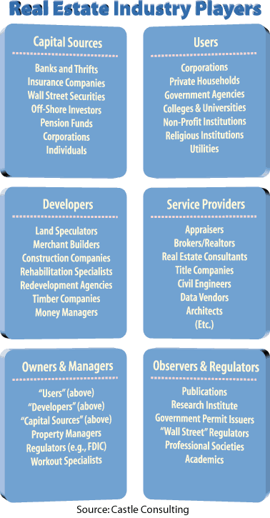
| 4. | Real estate is not a homogeneous, monolithic industry. Rather, the industry can arguably be divided into six broad categories of players encompassing approximately 40 niches; see the accompanying exhibit. Each of the 40 niches has unique problems to be solved, which translate into at least 40 GIS opportunities. |
| 5. | Data bases required to capitalize on these opportunities already exist in GIS compatible formats. This is no small issue, of course, given that data-related expenses comprise 70% to 90% of the cost of a GIS � especially a real estate GIS. Real estate professionals need such readily available digital files as county and city boundaries, zip code zones, census tracts, and street networks (especially for address matching). They need widely available demand-side attribute data such as projected population, household income, office employment, wholesale and retail employment, and retail sales. They also need less widely available supply-side attribute data on construction starts, asking rents, vacancy rates, and total inventory of building space; the providers of such information, fortunately, frequently organize the data by county, city, zip code zone, and other standard GIS digital units. |
| 6. | Though the real estate industry is now becoming aware of the promise of GIS, few individuals and organizations have yet begun offering GIS products and services. Entrepreneurial opportunities are virtually unlimited vis-a-vis GIS software and hardware, digital and attribute data, consulting, custom programing, systems integration, and so on. |
Future columns will explore those opportunities, beginning with case studies of GIS applications in residential and commercial brokerage, appraisal, market ranking, property management, mortgage underwriting, etc. Future columns will also examine promising new technological developments that few, if any, companies have yet transformed into GIS offerings for the real estate industry; examples include artificial intelligence/expert systems, and Global Positioning System (GPS).
The bottom line: The overall purpose of this column is to be educational. Accordingly, your comments and questions, and especially your case studies or other insights into the use of GIS in real estate, are most welcome.