|
"Location, Location, Location Drives GIS in Real Estate" The following text is Gil Castle's final draft of the real estate column appearing in Business Geographics, May/June 1993 Copyright © 1993 GIS World, Inc. |
In my real estate column in the January/February issue of Business Geographics, I discussed why real estate may well be the vertical industry with the greatest market potential for geographic information system (GIS) products and services. I also pointed out that few individuals and organizations have yet capitalized on that potential.
Among the pioneers are residential brokerage firms that use GIS with Multiple Listing Service data bases (see my column in the March/April issue) and the National Association of Realtors® (see the column in the current issue). In this article I provide a broad cross section of additional case studies. I also offer a framework for identifying untapped niche opportunities.
Case Studies
One can argue that the many firms using GIS for site selection (e.g., to open new retail outlets) significantly affect the real estate marketplace. One can also argue that the hundreds of planning departments, property tax assessment offices, economic development agencies, and related governmental organizations with GIS capabilities shape the real estate industry. One can even argue that timber companies, the largest private land owners in the nation and active GIS users for nearly two decades, play in the real estate arena.
Real estate is in fact one of the largest industries in the nation, but how about GIS applications in the "core" real estate functions of appraisal, brokerage, mortgage underwriting, property management, and so on? For nearly a decade I have been keeping track of every GIS user in real estate that I can find. I do not claim to have an exhaustive list, especially since some firms do not want the world to know about their GIS capabilities. Nevertheless, in my "known universe," three clusters of stars shine brightly: data vendors, service providers, and corporate users.
Data Vendors
Like every industry, real estate professionals need demand-side, supply-side, and market equilibrium data. The demand for real estate correlates to numerous socioeconomic variables � population, income, employment, household expenditures, and so on. The supply of relate estate derives from total inventory, construction starts, demolitions, etc. Equilibrium measures include vacancy rates, rents, and transaction prices.
Numerous demand-side data vendors actively promote their information in GIS format, and even offer GIS software. Equifax, Donnelly, CACI, Claritas (to name a few) target a broad cross section of American industries, including real estate.
Vendors of real estate supply-side and equilibrium data are far fewer in number; those with GIS capabilities, fewer still. Such vendors thus enjoy, at least temporarily, a quasi-monopolistic position in the marketplace. DataQuick® (San Diego, CA) provides real estate transactions data in GIS format. Appraisers, brokers, and other clients are able to spatially display on their computers all transactions satisfying certain criteria, and even overlay proximity circles from a subject property.
Landata (Houston, TX), a wholly owned subsidiary of Stuart Title Company, was founded in 1977 to automate the title insurance industry. For Harris County, Texas, Landata has built a GIS that links parcel maps with an estimated 2,000 real estate documents received in Harris County offices each day. Title company staff, brokers, builders, bankers, developers, appraisers�all can conveniently access data on specific properties of interest with the system.
Geospan Corporation (Minneapolis, MN) has vans driving all the urban streets in the U.S., taking stereo-pair photographs of all properties along the way. In the roof of each van is a Global Position System (GPS) receiver, which determines from orbiting satellites the van's longitude and latitude coordinates as the photographs are taken. With these coordinates, the photographs can be quickly linked to GIS maps. When data collection is completed in 1995, Geospan's clients will be able to click on a location on a GIS map of any city in the nation and promptly display photographs of the buildings at that site.
For these data companies, GIS is a conduit for selling their products. We now turn to firms that also use GIS to enhance internal operations.
Service Providers
Service providers include appraisers, brokers, real estate consultants, and related firms that offer professional assistance to the actual owners, occupiers, and financiers of real estate. For these firms, GIS can be a marketing device, provide a competitive edge, to obtain more business. However, GIS can also help these companies to improve their own productivity, credibility, and profitability.
For example, the real estate consulting divisions of Big Six accounting firms (e.g., Deloitte & Touche, Andersen Consulting) use GIS to assemble spatial analyses of market conditions when preparing feasibility studies, property valuations, expert testimony for law suits, etc.
Commercial brokerage firms (e.g., C.B. Commercial) find that GIS can help attract and serve more clients. GIS can help these brokers to efficiently and attractively assemble proposals, demonstrate detailed knowledge of local market conditions, and stay current on available space and rental conditions of properties in their area.
Residential brokerage firms (e.g., Better Homes & Gardens affiliates) link GIS tools with local Multiple Listing Service data bases; again, see my column in the March/April issue of Business Geographics. Moreover, a GIS was recently used to compile a 78 page atlas covering the United States as part of the 1993 edition of the RE/MAX USA Referral Roster; the atlas is valuable both to home buyers and brokers.
Investment managers acquire, administer, and dispose of real estate assets on behalf of institutional investors�typically large pension funds. This is a highly competitive and lucrative field, encompassing literally billions of dollars of real estate assets. A number of leading firms have investigated GIS technology, as an internal aid to better decision making (i.e., knowing when and where to buy and sell properties on behalf of their clients) as well as a marketing tool (to convince pension funds that they have better market data than competing investment managers). Nationally prominent investment management firms using GIS tools in various degrees include The RREEF Funds (San Francisco, CA), Equitable Real Estate Investment Management (Atlanta, GA), Karsten Realty Advisors (Los Angeles, CA), and GE Capital Corporation (Washington, D.C.).
Corporate Users
These are firms whose principal business lines are not real estate, but nonetheless have significant real estate holdings, and realize that their corporate profitability is significantly affected by how well they manage their real property. That is, they inventory corporate holdings in a GIS, and sometimes include other "layers" on market conditions (e.g., current vacancy rates and asking rents). They do so to identify and dispose of surplus real estate holdings, determine when renting might be more favorable than buying new facilities for corporate use (or vice-versa), and so on.
To some extent the following firms embody the most interesting case studies, because they have no marketing angle they are trying to pursue with GIS. Rather, GIS is being used purely to manage their operations more efficiently.
Railroad companies typically have extensive real estate holdings, and thus are prime candidates for a real estate GIS. CSX Real Property, Inc. (Jacksonville, FL) a subsidiary of CSX Transportation, faces two major challenges with the implementation of its real estate GIS. The first is the capture and editing of 28,000 real estate valuation maps and the subsequent digitizing of real estate assets. Coping with such a large volume of maps is accomplished with a combined raster and vector encoding methodology; valuation maps are scanned into the the system and edited with "heads up" digitizing. The second challenge is the integration of the resultant map base with CSX's current management information system. Task to task communications capabilities link the spatial database to CSX's host based real estate information system. This provides a transparent, real time link between digital maps and attribute data bases. The overall system, employing GIS software from ComGraphix (Clearwater, FL), is designed to operate as a decision support tool for the day to day management and disposition of real estate assets.
Chevron Corporation (San Francisco, CA) is one of the largest companies in the world, with correspondingly extensive real estate holdings. Charles Pastor is the Graphic Information Systems Coordinator of Chevron Real Estate Management Company (CREMCO). He reports that in 1988 Chevron began assembling a GIS data base on all its real estate holdings, as well as those of all its operating subsidiaries. Today all of Chevron's properties in approximately 800 U.S. counties are stored in an online GIS data base referenced to 1,500 U.S.G.S. quadrangles; the system uses software from Intergraph Corporation (Huntsville, AL). The spatial data are linked to Chevron's worldwide, corporate MIS, which is based on NOMAD data base management system software. The real estate information is updated weekly. Queries of the data can originate in NOMAD or in the GIS. Among the uses of the system are generating hardcopy maps of property boundaries for Chevron's in-house real estate professionals in the parent company and in the subsidiaries; responding to questions from brokers and other external parties who want to know if certain parcels belong to Chevron and what the status of those parcels might be; and providing a spatial reference (e.g., a building footprint on a local area street map) to facility managers and office space designers who are charged with refitting the interior of Chevron buildings. The real estate GIS is used daily. Chevron executives have recently found the system to be especially useful, because disposing of surplus properties has been a high priority.
Moving from traditional industries to the world of hi tech, Sun Microsystems Computer Corporation (Mountain View, CA) has an evolving system which combines real estate asset management and facilities management. With leases worldwide, Sun managers need simple and convenient access real estate information at the facilities level and at the Executive Information System (EIS) level. According to Kenneth Morrison, Facilities Systems Manager, Sun had been using CAD technology, but recognized the need to move to GIS. The reasons were twofold: Sun needs to associate data with facilities, and do spatial processing (e.g., find all assets "near to" something else). As a first step, Sun has geocoded 170 U.S. properties, using GIS software from ESRI (Redlands, CA) and digital maps from GDT (Lyme, NH). Data about each property, such as lease dates and square footage, are stored in a SYBASE database. By clicking on a property (shown as a symbol) on a the terminal screen, the attribute data can be retrieved and displayed. Interior and exterior photographs can also be retrieved (via Kodak Photo CD), as well as CAD drawings (via Postscript or TIFF).
Even Hollywood is getting into the act. Greg Park, Director of Computer Aided Facility Management for USCAD (Irvine, CA), says that several leading entertainment companies are exploring GIS and CAD tools to more efficiently utilize sound stages and other production facilities. With millions of square feet under management, these companies realize that they are losing substantial revenues by not having accurate information on when spaces of certain sizes, configurations, and recording characteristics will be available for rental. The problem is analogous to keeping a massive jigsaw puzzle as completely assembled (i.e., rented) as possible, when the pieces of the puzzle are constantly changing their size and pattern. Every additional television show, movie scene, rock video, etc., that can be accommodated due to better space management translates directly into a better bottom line.
Whether the focus is on square feet or square miles, the principles are the same. GIS can indeed be an effective tool for optimizing the use of and investment return on real estate assets.
Untapped Niche Opportunities
The previous case studies illustrate the diversity of GIS applications in real estate. How can we see the overall picture of real estate opportunities?
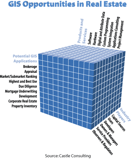
Referring back to my January/February column, I identified six broad categories of real estate industry players, encompassing about 40 subcategories. To a greater or lesser extent, each of these groups engages in a series of standard real estate functions: appraisal, brokerage, mortgage underwriting, property management, and so on. The industry players can therefore be arrayed against these real estate functions to form a two-dimensional matrix containing many cells.
Further, when considering GIS opportunities, we have many types of products and services: software, hardware, data, consulting, systems integration, custom programming, and so on. Each of these products and services are relevant to each of our previous matrix combinations. That is, we end up with the three dimensional matrix shown in the accompanying exhibit.
Note that each matrix cell in the accompanying exhibit represents an opportunity for providing a specific product or service to a specific group of players for a specific job activity. Note further that the matrix contains nearly 500 cells, even without expanding the players from 6 to 40 (lower right axis), or the real estate functions (left vertical axis), or number of products and services (top, horizontal axis). Note finally that of the 500 or so cells, few currently have any significant GIS activity; none take advantage of the full power and sophistication of GIS.
Essentially, each cell represents an untapped real estate opportunity. The world is waiting.
(For further information, the real estate column in future issues of
Business Geographics will provide detailed case studies, software
applications, data sources, and so on. Also, GIS World will again be sponsoring
its multi-day "GIS in Real Estate" workshop in mid-May and mid-December,
1993. Finally, GIS World's Profiting from a Geographic Information System
has an extensive chapter on the real estate industry.)