|
Property Tax Journal, April 1993 |
Context
Real estate is one of the largest sectors of the U.S. economy. Studies have shown that real estate accounts for approximately one-half the nation's wealth, and about one-fourth of the Gross Domestic Product . To coin a phrase, "What's good for real estate is good for the country."
Unfortunately, the last several years have been among the worst since the Great Depression, especially for commercial real estate. The reasons are not hard to find. For example, in the largest 50 markets in the U.S. construction of office and retail space exceeded net absorption every year from 1980 through 1990. At the same time that a huge oversupply of space was accumulating, demand for space was beginning to decline. During the 1990s, growth in office employment, households, and similar key components of demand have been and are projected to continue to be significantly below the levels experienced in the 1980s. Excessive supply, diminishing demand ó this is a bad combination for any enterprise, but especially one as highly leveraged as the real estate industry.
What is the silver lining to this storm cloud? As is true of most U.S. businesses in these recessionary times, real estate organizations are returning to economic fundamentals. The "Art of the Deal [Maker]" is giving way to the "Science of the Market Analyst." A realistic (if not conservative) multi-year pro forma, built on solid demand- and supply-side figures, with plenty of sensitivity testing of all assumptions, is becoming mandatory. Especially as an ever larger portion of U.S. real estate is controlled by fiduciary-driven pension funds, sophisticated offshore investors, and institutions under microscopic scrutiny by government regulators (e.g., banks, insurance companies, Wall Street securities firms), the pressure is on for project files to bulge with credible market data.
To efficiently and effectively assemble, verify, analyze, and reproduce significant amounts of market data, however, requires computers. Among the computer technologies holding the greatest potential for dramatically changing the real estate industry is Geographic Information Systems (GIS). Essentially, GIS is a powerful joining of computerized mapping with data base management systems. In real estate terminology GIS is, happily, all about "location-location-location."
The principal objective of this paper is not to serve as a primer on GIS; many educational alternatives are already available to fulfill that purpose. Rather, the focus will be on the specific relevance of GIS to the real estate industry today and tomorrow. The first section below will posit several principles on the who/what/when/where/how of successfully applying GIS to various needs of the real estate industry. The second and third sections will review case studies of real estate-related GIS projects in, respectively, the private and public sectors. The final section will offer conclusions regarding the most viable uses of GIS in real estate.
Principles
Notwithstanding the admonishment that "Every complex problem has a simple to understand, wrong answer," the following are Seven Key Things To Remember about using GIS in real estate:
|
1. |
GIS is a potentially far-reaching technology that is just now starting to be noticed in the private sector, not unlike a few years ago when spreadsheets, personal computers, and fax machines were a novelty. As with those other technologies, in future years people will wonder how they ever got along without computer mapping. |
|
2. |
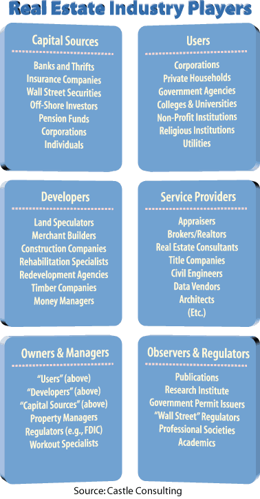
Real estate is not a monolithic industry. Rather, the industry is comprised of a great diversity of professionals (and amateurs) in a multitude of niches. Exhibit 1 is one categorization scheme of niches and sub-niches, each with its own needs, methods, tools, and so on. Consequently, the real estate industry does not need one GIS, but rather many different types of GIS. |
|
3. |
GIS can be effectively used within an organization to promote better decision making. GIS can also be effectively used externally, however, as a marketing device. Indeed, many of the GIS pioneers in the real estate industry have used and are using the visualization strengths of GIS to demonstrate to potential clients that they have their act together better than the competition. |
|
4. |
Just as GIS has applications that vary by industry niche, and that vary by decision support versus marketing objectives, GIS applications also vary by type of real estate analysis. "Generic" analytic functions to which GIS capabilities need to be adapted include appraisal (especially the income and comparable sales approaches), brokerage, market ranking, asset management, development, mortgage underwriting, and so on. These categories are used below to organize the case studies. |
|
5. |
Though most people at first blush view GIS as a means of generating pretty pictures, the greatest strength of the technology lies in GIS as a data base management system (DBMS). Virtually every type of information can be tied to some type of location, e.g., a street address, zip code zone, city, state, Longitude/Latitude coordinate, or whatever. GIS tools integrate and analyze data sets based on their locations. Thus, GIS embodies a universal means for linking together any and all information sources ó a powerful DBMS capability, indeed! |
|
6. |
As a corollary, GIS is likely to eventually be at the heart of Executive Information Systems (EIS) in the real estate industry. No other "common denominator" technology currently appears like to be able to cope with the diversity of niches, objectives, and analytic functions delineated above. For the moment, though, most GIS users in the real estate industry are examining one tree at a time, rather than trying to comprehend the whole forest. |
|
7. |
GIS can be, but certainly need not be, a stand-alone technology. Linkages already exist between GIS modules and selected spreadsheets, multi-media packages, artificial intelligence/expert systems programs, to say nothing of numerous DBMS products. GIS embodies a powerful set of tools, but those tools can provide even greater value-added when used in concert with other technologies. |
A final point transcends GIS, because it is a universal truth that applies to all computer systems, and should never be forgotten: "Garbage In, Garbage Out." A GIS can be used to spot inaccuracies, and especially absurdities, in data bases -- but cannot turn bad information into good.
Private Sector Case Studies
Again, GIS is in its infancy in private sector applications. The bad news is that comprehensive, sophisticated, field-tested applications of the technology are not yet available. The good news is that numerous organizations and individuals are going to become highly successful, famous, and/or rich by being the first to develop GIS uses in real estate.
Here, briefly, are some of the applications and competitors who are already out of the starting gate:
Brokerage. "Wouldn't it be great if a real estate agent could sit at a computer terminal with a home buyer, call up the local multiple listing service (MLS) computer, type in criteria ó on price range, number of bedrooms, etc. ó and then see a map on the screen showing the locations of all currently available houses fulfilling the criteria, plus the locations of schools, parks, bus routes, and and other neighborhood amenities of interest?" Yes, absolutely, and quite a few people have been pursuing that particular dream. For various technical, business, and political reasons, surprisingly few such systems are actually operational. In systems that are being used, the homes meeting the criteria are downloaded to the agent's computer, a GIS in the agent's computer matches the addresses of the selected homes with street maps in the computer's memory, and then the GIS displays the locations of those homes and other requested locations of interest (e.g., schools) on the terminal screen.
Appraisal. Similarly, "Wouldn't it be great if an appraiser could dial up the "market comps" data base offered on a vendor's computer, provide criteria on the property type and transaction date, and perhaps even on the vicinity of interest ó say, within a five mile radius of a subject property ó and then have all the real estate transactions meeting the criteria be displayed on a map on the computer screen?" Again, yes, and an increasing number of vendors around the country are providing rudimentary capabilities to their clients. These systems work in a very similar manner to the above MLS system.
Market Ranking. Investment advisors for pension funds, banks, insurance companies, major property management firms, and other real estate organizations that control large portfolios of debt or equity assets have a need to periodically "score" cities around the nation vis-a-vis their investment attractiveness. That is, what cities (if any) show promise for yielding a decent return on investment? What cities appear to be headed toward declining rents and capital depreciation? To the extent that a real estate portfolio does not contain holdings in the former, the organization might want to go shopping; conversely, if it has holdings in cities in the latter category, quick dispositions might be appropriate before other players recognize the trend line. Investment managers for pension funds, in particular, have used GIS to display basic demand-side and supply-side variables for, typically, the largest 50 Metropolitan Statistical Areas (MSAs) in the nation. After segmenting, combining, weighting, and otherwise manipulating the variables in proprietary models, the investment managers generate investment scores for all the MSAs. They can then display the scores, colored symbols, or other graphics on a map of the U.S.
Due Diligence. (Seemingly) never before have so many been so burned by so few reliable due diligence analyses as during the 1980s. With a GIS, a proper due diligence on a real estate transaction need not require blood, sweat and tears to achieve a financial victory. Extensive demand-side and supply-side data, at the regional, market, submarket, and individual building levels can be readily assembled, inter-related, analyzed, and displayed. GIS exhibits in the due diligence document included socioeconomic variables by census tract, the locations of competitive properties, major transportation facilities, and so on.
Mortgage Underwriting, Risk Management, and Capital Preservation. During the last half-decade a frightening number of thrifts and banks have failed, based in no small part on their residential and commercial mortgage portfolios. More often then not, a close examination of the underwriting systems of financial institutions reveals significant deficiencies in the ways that market-specific information is gathered, analyzed, and combined with other underwriting factors (such as the credit worthiness of the applicant). With GIS, financial institutions now have a cost-effective means for monitoring current and projected demand-side and supply-side data affecting the performance of real estate assets, at varying levels of geographic resolution. They can thereby better estimate the percentage of mortgages in each locale that might become "non-performing" or, worse yet, "real estate owned." Moreover, the institutions can use the GIS to demonstrate to government regulators that they have a good handle on the current and pending problems in their portfolios, and accordingly that the regulators need not impose draconian oversight measures.
Development. Given the severe demand-supply imbalance for commercial real estate, and given the non-trivial problems affecting residential real estate (e.g., a hiatus in construction financing), the development industry does not have much to do. Indeed, some estimates have shown that the number of developers operating in the United States has been halved since the mid-1980s. Among the survivors are those development firms which have assembled detailed, credible data bases on market conditions in the regions where they work, in order to best estimate the locations where new product has a decent chance of being profitable. Once again, a GIS is a remarkably useful tool.
Corporate Real Estate. Roughly three-fourths of the debt and equity capital invested annually in commercial real estate comes from corporations whose businesses are not real estate-related, i.e., the IBMs, AT&Ts, DECs, GMs, and a huge number of smaller companies that simply need space in which to operate. Especially in these lean and mean times, corporate executives are realizing that their real estate embodies one of their largest opportunities for significant improvements to the bottom line. Real estate expenditures are typically the largest budget expenditure after payroll, 25% of assets on the corporate balance sheet, and two times net profits. Real estate should therefore be managed as a profit center rather than cost center. For example: surplus properties can be identified and sold; leasehold interests can be sold and the corporate operations in that space shifted to lower rent facilities; and properties owned and occupied by the corporation can be recapitalized in a sale-leaseback arrangement, liberating cash without requiring a move to another building. A GIS can not only monitor the locations and magnitudes of a firm's real estate commitments, but also the changing market conditions where those assets are situated.
Community Reinvestment. Congress passed The Home Mortgage Act and The Community Reinvestment Act of 1977 to motivate financial institutions to meet the borrowing needs ó including construction financing and mortgages ó of the areas in which they are chartered to do business. To demonstrate compliance with the legislation, financial institutions need a method for spatially characterizing their trade areas (e.g., deposits received by census tract) and the products and services rendered (e.g., magnitude of loans made into those census tracts). GIS is very well suited for such analyses, as well as in "red-lining"studies.
The above case studies are not an exhaustive list. For example, how about the ever increasing use of GIS in selecting the best locations for franchise outlets? While a purist might say that retail site selection is not a "real estate" activity, obviously space use is involved, and the services of numerous real estate professionals are needed (brokers, appraisers, developers, and so on). Or, how about timber companies? Not only do they encompass the largest private land holdings in the nation, but many having been actively using GIS to to manage their assets for more than a decade. Pension funds have been diversifying their real estate portfolios by investing in timber commingled funds.
In short, real estate literally underlies everything and, accordingly, GIS opportunities are not difficult to find.
Public Sector Case Studies
To date, the vast majority of GIS applications have been in the public sector. No small percentage of the systems have been developed by assessors, urban planners, and other government officials who directly affect real estate markets. These uses of GIS are well documented, and need not be summarized here. (For example, a good overview of GIS in the assessors office can be found in the May/June 1992 issue of Assessment Digest.)
Still, a few areas are worth highlighting because of their relatively recent emergence and direct relevance to real estate industry:
Property Inventory. Some state governments, and undoubtedly numerous local governments, do not have current, accurate, or even complete records of the real estate they own, lease, have easements on, or otherwise control. Computer records in a data base management system are better than sheets of paper in a file cabinet ó and a GIS is better yet. A GIS can store, update, and display the exact sizes and configurations of parcels and improvements. A GIS can determine the spatial relationship between multiple parcels. A GIS can readily identify "holes" in the data base (e.g., "This GIS map shows no state holdings in Washington County...Is that accurate?"). A GIS can quickly relate real estate holdings to other important data "layers," such as jurisdictional boundaries, critical wildlife habitat areas, flood zones, slope, transportation corridors, and so on.
Asset Management. Similar to the Corporate Real Estate function described earlier, and especially in these tight budgetary times, government agencies should be carefully scrutinizing their real estate holdings. Revenues can be increased by achieving true market rents when leasing government land to private businesses, and by selling surplus properties. Expenses can be reduced by shifting governmental activities out of space that has excessive rents or carrying costs, and by simply monitoring and publicizing government space that is becoming available to other agencies or even to private businesses. Profitable, private-public joint venture opportunities can be found for redevelopment parcels, in the air rights over public buildings, and in other under-utilized real estate holdings. GIS tools can be instrumental in all these asset management activities.
Economic Development. This is a classic "win-win" situation. A successful economic development agency will increase the number of jobs available to citizens in its jurisdiction, expand the tax base, diversify the economy, and generally enhance community wealth. Businesses attracted to the jurisdiction will have benefit of more complete information for making rational location choices. With a GIS, the agency and prospective businesses can efficiently peruse maps showing the labor supply, transportation network, utilities, tax rates, available parcels, asking rents, and so on. In this setting, a picture is indeed worth a thousand words.
Selling Data. A hot topic at GIS conferences has been and continues to be public agency sales of GIS data. An intimidating set of legal, technical, managerial, financial ó to say nothing of political ó obstacles must be over come. The motivation, of course, is the substantial revenue stream theoretically achievable through leveraged use of already existing data bases. This is another potential "win-win" situation; government agencies collect user fees, and real estate professionals ó title companies, appraisers, brokers, developers, mortgage underwriters, etc. ó gain access to valuable information. As a corollary, the concept is sufficiently enticing that a number of companies around the nation have been approaching government agencies with proposals to create, donate, and maintain a GIS data base in exchange for rights to sell the information to private sector clients.
The Future
The world is always ready for the proverbial "better mouse trap" (given, of course, in-depth research on mouse behavior, clever marketing, appropriate pricing, timely product delivery, sufficient quality control, solid customer support, and so on). GIS embodies the potential for lots of better mouse traps.
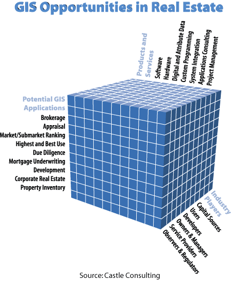
As summarized in Exhibit 2 focused GIS products and services ó software, hardware, data, consulting, education -- are needed, for numerous combinations of industry niches and analysis functions. This paper has provided a snapshot of the initial activities happening within some of the matrix cells in Exhibit 2. Most of the cells in the matrix are empty. Whether one works in a public agency, private company, academic institution, or non-profit organization, the opportunities for developing GIS applications in real estate are virtually endless.
The Bottom Line: Real estate is essentially a game of information arbitrage; GIS, an excellent means for keeping track of everything on the game board.
References
1992
William A. Rodda, CAE, "Appraisal Uses of GIS," Assessment Digest, International Association of Assessing Officers, May/June 1992
David Churbuck, "Geographics," Forbes, January 6, 1992
John O. Behrens, "Nationwide Real Estate Sales Database Has
Numerous Uses," GIS World, March 1992
1991
Laura Lang, "Hot Property: Geographic Information Systems
Technology Gains Ground in Real Estate Applications,"
Computer Graphics World, December 1991
Grant Ian Thrall, "Reducing Risk: A GIS Design for Real Estate
Analysis," Geo Info Systems, November/December 1991.
Jack Dangermond, "Business Adapting GIS to a Host of Applications," GIS World, October 1991
Glenn R. Mueller & Michael J. Robbins, "Eighth Annual Software Review," Real Estate Finance, Federal Research Press, Spring 1991
1990
Stephen E. Roulac, Lloyd Lynford, and Gilbert H. Castle, III, "Real Estate Decision Making in an Information Era, Real Estate Finance Journal, Summer 1990
Bruce R. Weber, MAI, "Application of Geographic Information Systems to Real Estate Analysis and Appraisal," The Appraisal Journal, American Institute of Real Estate Appraisers, January 1990
Kenneth Dueker and Barton DeLacy, "GIS in the Land Development Process," American Planning Association Journal, Autumn 1990
Robert H. Pittman and Maury Seldin, CRE, "Real Estate Analyses Using Geographic Data," Real Estate Issues, American Society of Real Estate Counselors of the National Association of Realtors®, Spring/Summer 1990